Submitted by bog on Fri, 09/29/2023 - 10:41
Just when you thought handheld trail GPS was dead because of smartphones, along comes the Garmin GPSMAP 67 and 67i. (These two units are identical except the 67i has built-in InReach, which provides two-way satellite messaging and SOS services via a subscription service. If you buy the 67, you can always pair it with a separate InReach communicator at a late time. All the features I'll discuss below are common to both units.)
The GPSMAP 67 series adds three major features:
Submitted by bog on Sat, 06/20/2020 - 12:08
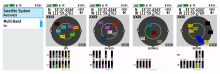
Satellite pages from a Garmin GPSMap 66s showing the GPS and GLONASS status screens
The GPSMap 66 series are the first trail receivers from Garmin to use both the Russian GLONASS and European Galileo satellite navigation systems. On the Satellite Setup page, you have a choice of using GPS (NavStar) only, or GPS+GLONASS, or GPS+Galileo. The advantage of using Galileo or GLONASS with GPS is that you have more satellites in the sky, which improves the quality of your position fix, and increases the receiver's accuracy and ability to maintain a position fix with a partial view of the sky. Note the 10-foot accuracy in the above screenshots. In my location in northern Arizona, more GLONASS satellites are usable than Galileo satellites, but you'll need to experiment under your own conditions.
Submitted by bog on Mon, 01/14/2019 - 07:05
I have a GPSMAP 66S, but what I have to say here applies to the 66ST as well- the only difference between the models is that the 6ST adds Garmin Topo maps. I prefer to load my own maps from gpsfiledepot.com, which are more detailed than Garmin's 100K maps and are free. So, when I refer to the GPSMAP 66S below, I mean both models.
Before I get started, let me say that the positives in this unit far outweigh the negatives, at least for my use. The core function, that of locking onto satellites and determining your position, is significantly improved over the already excellent GPSMAP 64 series.
Submitted by bog on Wed, 12/05/2018 - 11:15
Since I don't drive a truck or an RV, I haven't paid much attention to the differences between GPS street navigators that are intended for passenger car use, and units designed for drivers of large vehicles. But the differences are important! Both truck and RV GPS units allow you to enter the dimensions of your vehicle so that it can route you to avoid low overpasses and roads that are unsuitable for your vehicle. In addition, the trucker units include truck stops and other truck services in their POI databases, Likewise, RV units include RV parks and services in their POI databases.
Submitted by bog on Wed, 12/05/2018 - 08:58
As my regular readers know, I'm a fan of the button-operated GPSMAP series from Garmin. So I was excited to see the new GPSMAP 66 series released. At first, it didn't seem like this was much of an upgrade from the GPSMAP 64, but a closer look revealed that some long-awaited features have been added. So I decided to order one to check it out. Until it arrives and I can evaluate the unit in the field, here's some thoughts on the new features.
Submitted by bog on Thu, 07/19/2018 - 14:55
After extensive use of various apps on my Android phone, as well as the Garmin GPSMAP 64s and Garmin Oregon 600 handheld GPS receivers, I've reached some conclusions as to which options are acceptable for critical use (meaning failure could be life-threatening) and non-critical use (where failure would be inconvenient but not life-threatening). Here's a list of advantages and disadvantages for each:
Garmin GPSMAP 64s
I strongly recommend the Garmin 64s for critical use in the wilderness (wilderness meaning remote areas where there are neither roads nor motorized access.)
Submitted by bog on Sun, 03/11/2018 - 09:08
As more people, including myself, increasingly rely on my smartphone for street navigation, there's one glaring advantage that dedicated street GPS units still have- they don't report your position constantly. (All smartphones with Google Maps installed report your position to Google, unless you've turned off location services in your phone.) The purpose of this position reporting is to collect data points which Google uses to generate the traffic data on their maps- see en.wikipedia.org/wiki/Google_Traffic. Supposedly, Google strips all identifying information from the data points, and also deletes the starting and ending points of a trip, for privacy.
Dedicated street GPS units haven't had Internet connectivity and so couldn't report anything (except possibly during map updates.) But this is starting to erode. Most of the newer Garmin street GPS units to your SmartPhone via Bluetooth. The higher-end receivers also include Wi-Fi to make map updates easier, but that does mean your GPS receiver is connected to the Internet, with all that implies. Of course, you can disable these features, just like you can disable location services on your phone. But will you?
Submitted by bog on Tue, 04/12/2016 - 07:15
Submitted by bog on Tue, 03/22/2016 - 08:31
Submitted by bog on Tue, 01/05/2016 - 12:27
Now that I have a few months experience with the Garmin 64s and Oregon 600 in the field, I can say that the 64s is the best of the two. Although the touch screen on the Oregon 600 is very usable and is the best GPS touchscreen I've used, the Oregon's fatal flaw is that the software locks up. The screen freezes and the unit doesn't respond to any of the buttons. The only way to recover the receiver is to remove and reinsert the batteries. This happens several times a day and is simply unacceptable in a navigation device.
Pages